Text and images (c) Robert Barry Francos / FFotos by Francos, 2014
Photos can be
enlarged by clicking on them
After a harrowing Yellow River Raft ride, we emerged at the entrance-proper to the Yellow River Hoodoo National Geopark. At the mouth, there were numerous open donkey carts on one side and horses on the other, so one could choose how to travel the narrow road. Either way, you did went accompanied by a guide.
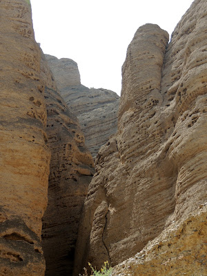
There were many rock formations that I believe may have been fashioned by man rather than nature, such as a monkey head, a bird and a common Chinese symbol. Point is, it was still super impressive. Along the way, you could see numerous rain gullies; it seems like it would be easy to flood the route, as water is what formed it in the first place. There were the occasional things that seemed out of place (i.e., modern technology), but it was an amazing ride for about a mile or two. The guide walked the mule one direction, and then jumped on the cart and let it find it's way home on the return.
There were large boulders that looked like they were about to drop, and others that obviously had. Also some places had large chucks missing from the wall where one could tell there had been a collapse at some point in time, though no evidence of it at the bottom.
After the tour, we boarded a motorboat - the same one that rocked the raft when we flowed down the river to get there - and you could see the farms on the other side of the river, and the mountain range going off into the distance. On the way via raft, I was too concerned about falling in the river to notice.
After we returned to the harbor, we took the motor cart to the bus, and headed up the switchback to the parking lot. Nearly three hours later, we were back in Lanzhou, having to pack to leave the next day.
 |
The entrance to the Yellow River Hoodoo National Geopark,
once you exit the raft. |
 |
| Guides sleeping out of the blazing hot sun, reflected off the rocks. |
 |
| The kind of mule cart we would soon be riding. |
 |
| Our Yellow River Rafts being driven back to Hongwiang harbor. |
 |
| Horses on the left, mule carts on the right. |
 |
| Our guide leading the mule and our cart. |
 |
| That rock on top looks like it's about to drop. |
 |
| That hole looks like the symbol for China. |
 |
| That rock looks like a sea shell; I'm wondering if it's natural. |
 |
| A side path not taken by us. |
 |
The little house at the bottom is where the guides register each tour
at the start and end, to make sure all are accounted for at end of day. |
 |
| Fallen rocks. |
 |
| Electric boxes in the middle of the Geopark trail. |
 |
| A house under some precarious rocks. |
 |
| Rock that looks like a bird on the top. |
 |
| Rock that looks like a monkey head; natural? |
 |
| Hoodoo that voodoo that you do so well! |
 |
| Rain gully with a shaft of light coming down. |
 |
| Looks a bit like Edvard Munch's "The Scream" face; I believe this is natural. |
 |
| This rock makes me think of a beehive. |
 |
An obvious place of rock collapse.
Looks like something took a bite out of it! |
 |
| Another place where it looks like a slab of rock let loose. |
 |
| Motorboating back. |
 |
| Farms along the opposite bank. |
 |
| Even this far out, the smog is noticeable. |
 |
| The mountain range goes on for quite a while. |
 |
| Ferry that crosses the river for the locals. |
 |
| Where we started. |
 |
| On the cart back to the bus. This is the curve our raft followed. |
 |
| I'm not sure if these are working water wheels, or now art. |
 |
That round object on the roof is a retractable solar panel.
The West is behind in this technology. |
 |
| Cooler for beer at local grocery store. |
 |
| Locals relaxing. |
 |
| Workers on break. |
 |
| Enjoying the wear. |


No comments:
Post a Comment